
Winter storm brings first snow to six states Monday
Web StoryWatch this story in 15 seconds →Key takeaways
- Six Plains and Rockies states face their first snow of the season through Monday.
- Several inches of snow are possible in the Black Hills of South Dakota.
- Alaska faces a separate, stronger storm with up to 16 inches of snow.
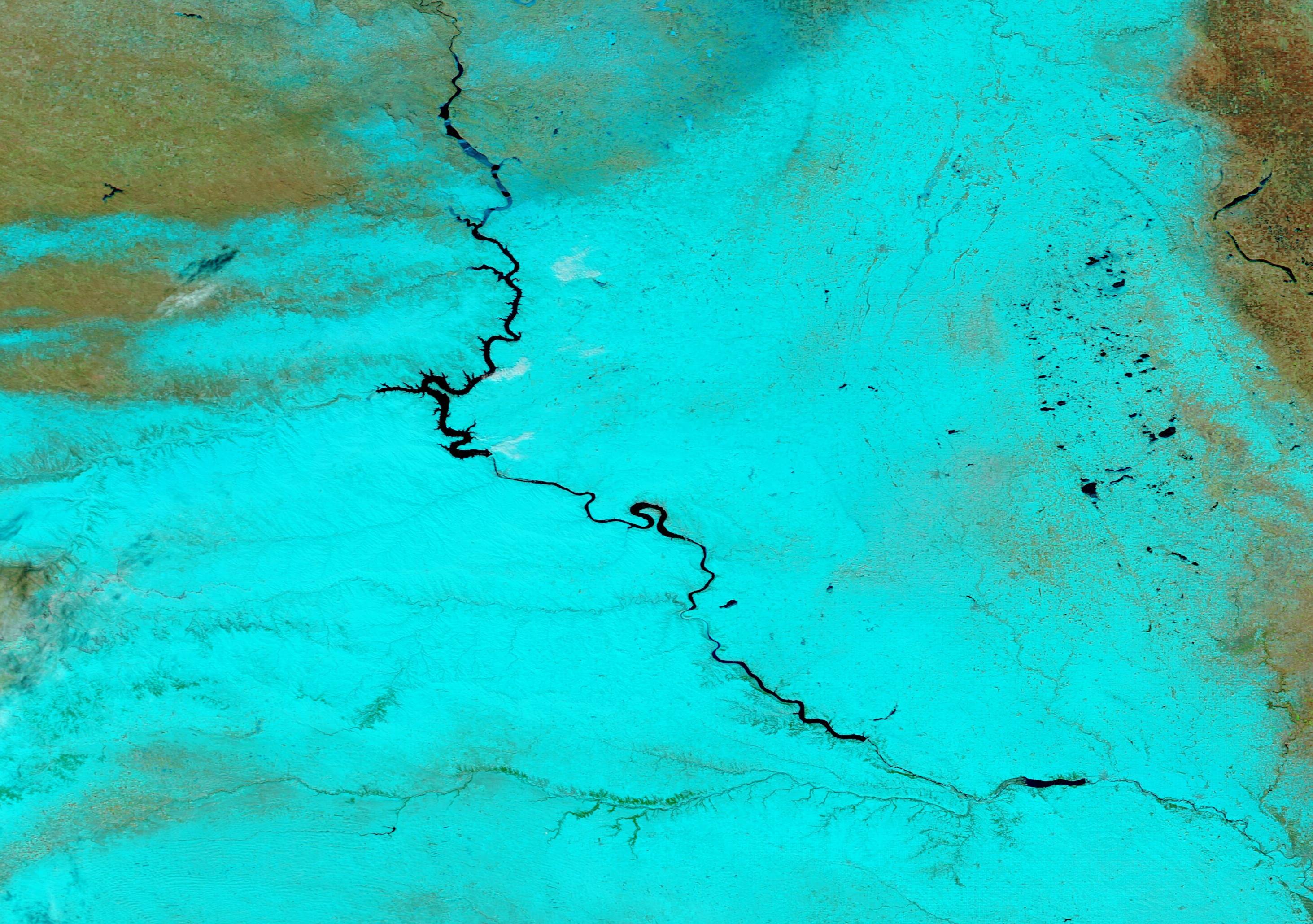
A slow storm is bringing the first snow of the season to six US states. The snow arrives from Sunday night into Monday night. The six states are Colorado, Wyoming, South Dakota, Nebraska, North Dakota, and Montana.
This is an early-season storm, not a mid-winter blizzard for most places. Still, it can make roads slick and slow travel. Drivers in the Plains should check local warnings before they leave home.
What happened
The storm started as heavy rain in the Southwest. It moved north out of the central Rockies and High Plains, according to FOX Weather. A strong high-pressure area over Canada then slowed it down.
That slowdown matters. It keeps rain and snow over the same areas for days. Cold air now moves into the region behind the rain.
AccuWeather issued its forecast on October 24 and updated it on October 25. The forecast calls this the first snowfall of the season for the six states. Men's Journal reported the forecast on October 25.
Where snow will fall
The heaviest snow looks likely in the Black Hills of South Dakota. AccuWeather senior meteorologist Bob Smerbeck said several inches could fall there. Rapid City could see slushy snow on Monday, he said.
Monday is when snow is most likely to fall hardest in Rapid City. Slush may build up on grass and unpaved surfaces first. Paved roads may stay wet rather than snowy at first.
Snow is also possible from eastern Wyoming and northwestern Nebraska into southwestern North Dakota. That band comes from the same AccuWeather forecast. FOX Weather adds a key detail about height.
A few inches of wet, slushy snow could build up above 5,000 to 5,500 feet. That height band covers the higher ground in the Black Hills. Lower ground should see rain first, then a mix of rain and snow.
Around Rapid City, rain could briefly mix with wet snow. Warm ground temperatures should stop much snow from sticking there, according to FOX Weather. Roads could still turn wet or briefly slushy.
Heavier snow may also develop farther east. AccuWeather warns of heavier snow in eastern Montana and western Minnesota. That snow runs from Sunday night into Monday night.
It falls outside the highest elevations, the forecast says.
Denver should escape the worst of this system. Most of the Colorado River basin should also avoid the bulk of it, according to AccuWeather. That is good news for a large city in the storm's path.
Rain and flood risk farther south
Snow is only half of this storm. The southern half brings heavy rain and flood risk. Parts of the Northern Plains could see 1 to 3 inches of rain.
Western South Dakota, western Nebraska, and eastern Wyoming are in that rain band. Parts of central North Dakota are also included, according to FOX Weather. Rain that heavy can flood low roads fast.
More than two million people were under some type of flood alert on Sunday. The alerts covered New Mexico, Colorado, and parts of Texas and Utah. West Texas still faced a Level 1 out of 4 flash flood threat.
Flash floods can rise fast, even where rain looks light. Drivers should never drive through flooded roads. The water depth is hard to judge from inside a car.
This storm is a good reminder that one system can bring two dangers at once. Snow hits the north while rain hits the south.
Readers in Sydney faced a similar split when storms brought floods and hail together. Heavy rain also caused record flooding in Queensland in a separate storm.
Alaska faces a stronger storm
Alaska faces a separate storm, and it looks stronger. The National Weather Service issued winter storm warnings for parts of interior Alaska. The warnings run through Monday evening.
Heavy snow of 8 to 16 inches is expected in the warned areas. Winds could gust as high as 35 miles per hour. That warning covers the southern slopes of the central Brooks Range.
Atigun Pass faces a separate advisory. Gusts there could reach 55 miles per hour. Blowing snow could cut visibility below one-quarter mile.
The Weather Service gave clear advice for drivers there. Keep an extra flashlight, food, and water in your vehicle. That advice fits any driver caught in a winter storm.
Alaska's storm is not the same system as the Plains storm. It is a second round of heavy snow in the north. Travelers in both regions face hazards on Monday.
What happens next
The Plains storm should move on after Monday night. Snow totals will then become clear. Local forecasts will show which towns got the most snow.
Travelers should take three simple steps before they drive. First, check local warnings and road conditions. Second, slow down and leave extra space behind other cars.
Third, keep a winter kit in the car. A winter kit needs a blanket, warm gloves, and an ice scraper. It also needs water, snacks, and a phone charger.
Cold tires lose pressure too, so check them before a long drive in cold weather.
Early snow can catch drivers off guard. Many cars still carry summer gear in late October. This storm is a good prompt to switch that gear now.
Forecasts can still change as the storm moves. Check one fresh forecast before you travel on Monday. A short check now can save a long delay later.
Related stories

Why Your Faucet Keeps Dripping After You Turn It Off
A dripping faucet is usually a worn washer, O-ring, or cartridge that can no longer seal. One drip per second wastes over 3,000 gallons

How to fix a running toilet without a plumber in 30 minutes
A running toilet can waste 200 gallons of water a day. Diagnose the flapper, float, or fill valve in two minutes, then fix it yourself

How to hang heavy shelves on drywall safely
Studs first, toggle bolts second, plastic anchors never for heavy loads. Weight ratings, installation steps, and mistakes that bring